Some Captured History of Glanamman and GarnantThe Origin of Cwmamman's CoalScientists generally believe that the earth is approximately 4.5 billion (4,500 million) years old and has undergone many natural changes since it's formation. They have split its development into several timespans called "Periods" to help them catalogue the events which made the earth into the way it is today. During what is known as the "Carboniferous Period" (The word means Coal Bearing in Latin), the continents were very different from the way they are today and the land which is now Cwmamman, lay somewhere near the Equator. The Carboniferous Period lasted from approximately 359 million years to 299 million years ago.
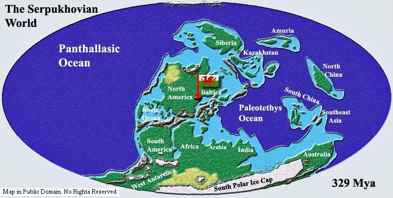
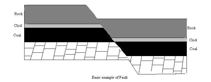
The above image shows the world as it was 329 million years ago. The red arrow next to the Welsh flag shows the approximate location of what became Wales. The climate was warm, resulting in tropical rainforests with huge trees and fern like plants covering the land. Some of the ancient trees which made up the lush forests would have been up to 40 metres tall. Much of South wales was covered with dense swamps, and what is now Cwmamman would have been unrecogniseable. Giant mosses and ferns added to the large accumulation of peat within these swamps. Over time, as the layers of peat became buried deeper and deeper, they became compressed and pressure together with heat from the earth resulted in the formation of coal seams which played an essential role in Britain's industrial revolution and caused the birth of the villages of Glanamman and Garnant. Over millions of years, tectonic forces (movements of the earths plates), carried England and Wales to join Scotland, making Britain complete. Cwmamman's current position on the earth is approximately 51.8 degrees North; 4 degrees West, but the European Plate on which Cwmamman sits, is moving away from the North American Plate at the rate of approximately 2cm per year. The same tectonic forces are responsible for squashing parts of the land together to make mountains and buckling the seams of coal, pushing them near to the surface in many places and making the coal easily accessable and cheap to produce. In Victorian times, the miners of Cwmamman were well acquainted with the coal seams in the locality, which were given names such as "The Peacock Vein", "Big Vein" or "Red Vein" for example. The Welsh word for Vein is "Gwythien" and the term "Gwythien Goch" or "Gwythien Fawr" would have been familiar terms to the men of Glanamman and Garnant. Coal from different seams would have differed in quality and depth. The hard anthracite coal extracted from Cwmamman and the western side of the South Wales Coalfield was among the best quality in the world, containing approximately 93% carbon. It burns with an intense heat, giving off relatively little ash or smoke, unlike the steam coal which was mined in the eastern side of the South Wales Coalfield. Faults, where the earths layers were broken, were a problem in the mining industry, especially in the anthracite region of the South Wales Coalfield. Where layers of coal have seperated due to a fault, one layer may be much higher or lower than the other, making it too expensive to reach from the current mine workings.
The miners of Cwmamman, would have been familiar with the faults in the area, these also having their own names such as the "Tyllwyd Fault," for example. Information for this page was taken from several sources, including the following websites "www.palaeos.com", "www.wales-underground.org.uk" and "www.wikipedia.org". Thanks to Augustus White for pointing out the location of Britain on the Serpukhovian Map.
|